


From Thalgau over Wartenfels to Fuschl
Die schnellste Verbindung zu diesem Ziel
From Thalgau over Wartenfels to Fuschl
THE PATH FROM THALGAU TO THE RUIN OF WARTENFELS AND FURTHER TO THE TOWN OF FUSCHL LEADS OVER A GENTLE ELEVATION. IF YOU PREFER IT MORE CHALLENGING, TAKE THE STEEP DETOUR VIA THE SCHOBER.
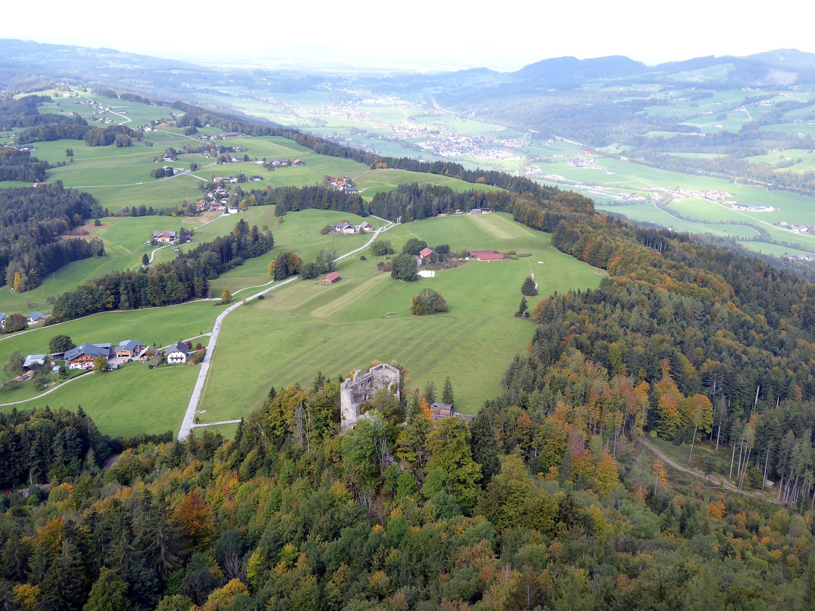
The orientation is easy: From the starting point in Thalgau, the striking Schober immediately draws attention. The rock ridge belongs to the Tyrolean Cover, which is responsible for prominent mountains such as Hochstaufen, Nockstein, or Traunstein and closes the Northern Limestone Alps along this line. However challenging the last 300 meters in elevation to the Schober are, the solitary path there is harmonious and opens numerous lasting landscape impressions. Also wonderful is the view from the easily accessible, historic ruin of Wartenfels back towards Thalgau. Until 1564, the castle was the seat of the caretaker; with the construction of the new courthouse in Thalgau, its decline began. It is definitely worth seeing before the path leads directly, or for sure-footed hikers via the Schober, down to the romantic Lake Fuschl.
Direct access and details at: salzburg-erfahren.at
mittel
3h 0min

9.00 km

Familienfreundlich

A nach B

Thalgau

Jahreszeiten


Wegbeschreibung
From the Thalgau town center bus stop, the path leads past the church, turns right before the Spar market onto Fuschlerstraße, crosses the bridge after 400 m, and then follows the signage on the left for "Ruin Wartenfels, Schober. Path 18." The Schober with its striking rock formation appears immediately; the route 18 leading there initially follows the access road (Wartenfelserstraße) and then ascends more steeply through the forest on a service road after the last houses. After this first steep stage, the terrain opens again; the sunny path turns left before a chapel, shortly after turns right, and merges into the 2 km long access road "Wartenfels." After a total of 2 hours, reaching the inn at the end of the road, the 15-minute climb to the ruin of Wartenfels is a very recommendable enjoyment, while the equally possible one-and-a-half-hour crossing of the Schober (1,328 m) must be described as difficult and demanding. With or without summit—the one-hour descent to Fuschl follows path 10 past the golf course and the Waldhofalm. The lakeside promenade in Fuschl offers lovely places to rest and eat before the hike ends at the Fuschl town center bus stop opposite the parish church.
Informationen & Kontakt
www.thalgau-tourismus.at; www.fuschlsee.salzkammergut.at
Mag. Christian Heugl
5400 Hallein
Photo credit: Christian Heugl
Anfahrt mit den Öffis
By bus 140 from Salzburg central station (Suedtiroler Platz) to Thalgau town center. Return by bus 150 from Fuschl town center to Salzburg central station (Suedtiroler Platz).
Timetable information and download: Online at www.salzburg-verkehr.at or on your smartphone via the free Salzburg Verkehr app for Android and iOS.
Direct access and details at: salzburg-erfahren.at
Streckenprofil
Alle vorliegenden Inhalte hat die Redaktion nach bestem Wissen recherchiert. Die Redaktion der Salzburger Verkehrsverbund GmbH kann aber keine Gewähr für die Vollständigkeit, Korrektheit und Aktualität übernehmen. Wir bitten Sie, bei der Ausflugsplanung die Angaben zu überprüfen, da sich Öffnungszeiten, Eintrittspreise oder Informationen ändern können. Haftungsansprüche gegenüber der Redaktion oder der Salzburger Verkehrsverbund GmbH, welche sich auf Schäden materieller oder ideeller Art beziehen, die durch die Nutzung der dargestellten Informationen bzw. Nutzung fehlerhafter und unvollständiger Informationen verursacht wurden, sind grundsätzlich ausgeschlossen.