


Riedinger Waterfalls and Hut Hopping at the Foot of the Hochkönig
Die schnellste Verbindung zu diesem Ziel
Riedinger Waterfalls and Hut Hopping at the Foot of the Hochkönig
From the Arthurhaus on the Salzburger Almenweg to the Dientner Sattel
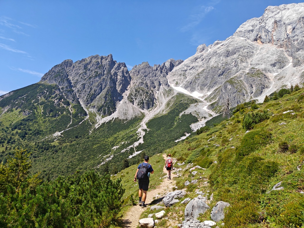
The Arthurhaus, set against the backdrop of the Mandlwände, is the starting point of this beautiful route hike on the sunny side. Fortunately, the hiking bus regularly runs to this lovely starting point. Steep alpine meadows where cows graze line the path to the Riedingtal waterfalls. After an ascent, you eventually reach the four huts – plenty of choices for refreshments. The path undulates through dwarf pine along the Salzburger Almenweg, finally passing the Stegmoosalm up to the Dientner Sattel. There you can stop at the mountain inn Mittereggalm until the bus arrives. Pure pleasure hiking.
leicht
3h 10min

9.85 km

A nach B

Muehlbach am Hochkoenig

Jahreszeiten


Wegbeschreibung
From the bus turnaround at the Arthurhaus, there is an immediate yellow signpost. Follow the wide Königsweg left through a cattle grid heading west. It passes through two small forest sections to the Windrauchegg Alm – the first opportunity to stop for refreshments. After the hut, continue on the forest road, which gently descends above the Riedingalm to the Riedinger waterfalls. The detour to the waterfall rewards hikers with a cool refreshment. Cross the creek again back to the path, which now steadily ascends via a trail to the four huts. Here you have a wide choice for refreshments: the Scharten Hütte, Molteraualm, Brandstathütte, and a bit below the Berghüttn complete the quartet. Afterwards, the path becomes narrower and continues along the contour line heading west. You enter a belt of dwarf pine below the Birgkar and finally stand above the Steegmoosalm. Here, do not take the first signpost to the alm but walk a bit further to the next sign. Then descend left over the alpine pasture and light forest heading south. Via a forest road, you finally reach the Birgkarhaus at the Dientner Sattel. Here the hiking bus stops, and possible waiting times can be spent at the mountain inn Mittereggalm.
Informationen & Kontakt
Information & Contact
Stefanie Ruep
5020 Salzburg
stefanie.ruep@gmail.com
@stefitzka
Photo credit: Stefanie Ruep
More info on the Salzburger Almenweg and the Hochkönig holiday region
Anfahrt mit den Öffis
Arrival: IC or Rex to (H) Bischofshofen, change to bus 590 to (H) Mühlbach am Hochkönig Neubaubrücke, change to hiking bus 593 to (H) Arthurhaus
Return trip: (H) Dientner Sattel bus 593 to (H) Mühlbach am Hochkönig Neubaubrücke, change to bus 590 to (H) Bischofshofen, IC or Rex
Timetable information and download: online at www.salzburg-verkehr.at or on your smartphone via the free Salzburg Verkehr app for Android and iOS.
Streckenprofil
Alle vorliegenden Inhalte hat die Redaktion nach bestem Wissen recherchiert. Die Redaktion der Salzburger Verkehrsverbund GmbH kann aber keine Gewähr für die Vollständigkeit, Korrektheit und Aktualität übernehmen. Wir bitten Sie, bei der Ausflugsplanung die Angaben zu überprüfen, da sich Öffnungszeiten, Eintrittspreise oder Informationen ändern können. Haftungsansprüche gegenüber der Redaktion oder der Salzburger Verkehrsverbund GmbH, welche sich auf Schäden materieller oder ideeller Art beziehen, die durch die Nutzung der dargestellten Informationen bzw. Nutzung fehlerhafter und unvollständiger Informationen verursacht wurden, sind grundsätzlich ausgeschlossen.